วันจันทร์ที่ 23 มีนาคม พ.ศ. 2552
Festivals & events what's happening on the local scene
Local flavor from food to handicrafts
Well-known foods from Satun "Roti assorted with banana",
"Roti with curry", "Mataba", Tareh coffee", and hot tea with milk are served at "Mae Roti" on Tamma-ngong Uthit Road, Amphoe Muang Satun. "Pa Samod" or Muslim Salad and Ancient Noodles are served at "Sofia Restaurant" at Km. 10 Tambon Ban Khuan, amhoe Muang Satun Tel. 074-721055. open at 06.30 AM. till midnight. Local desserts such as "Bada", "Kouy Guda" and "Mamode" or "Labanoon" are on sale at Satun Market, 05.00 AM. - 07.00 AM."Jumpada" (a kind of jack fruit) is available at Satun Market during June.
Ko Khai (Khai Island)

A large stone arch or "stone gate" in Ko Khai becomes a logo of Tarutao National Park. During November and January large sea tortoises come ashore and lay eggs on the beaches. Beautiful beaches are ideal for swimming. Further down are large clusters of beautiful corals which can be seen through the crystal clear water during the tourist season.
Ko Hin Ngam ( Beautiful Stone Island )

Because of its natural wonder, Ko Hin Ngam, part of Adang archipelago, has attracted and inspired visitors from faraway lands to witness the unspoiled beauty of the island. Ko Hin Ngam or Ko Pulo possesses beautiful stones polished and shaped by the everlasting waves hitting the shores year after year. The smooth and shiny surfaced stones of various sizes , shapes , and colors are an amazement to the sight of the beholders. On this island one can find these stones in black, blue, brown, red, mixed colors or stripes in round, oval, and other shapes. The beaches on the island can be best admired when the sun shines and the waves splash on the stones.The shiny glittering surfaces of the stones reflect the glaring sunshine while the blue waves splash the beaches providing ecstasies for those who witness the event. Of particular joy is the sunset when the last orange rays of the sun touch the pure white foams of the waves giggling on the stones. This memorable scene defies description. To reach Ko Hin Ngam , visitors make a stop at Adang or Lipe islands first rather than proceeding directly to and staying overnight at Ko Hin Ngam as no accommodation is available on the island .
Ko Li-Pe The land of the sea gypsies

Nearby islands familiar with vacationers are Li-pe or Nipis Island (meaning "thin" island in Malay). Lipeh is an island in Adang archipelago, one kilometer south, and 25 kilometers west of Tarutao island. Formerly Lipe was not inhabited. According to the "Report on the Survey of Tarutao National Park" published by Mahidol University in 1977 , the first settler on the island was an Indonesian named Hili (pronounced "ngi-li" by the locals). On his business missions, he was a regular traveler to Penang and Siam and found a settlement first in Ko Mai Kadan Island and married a sea gypsy woman. Later he moved his trading post to Ko Bulon and finally to Ko Li-pe. During his early settlement, he had to travel to Satun to buy rice, using a row boat. He picked up coconuts which floated to the island and planted them there. Any fishermen who came to fish near the island were invited to settle on the island.  (According to other sources, a man named Nai Mahmad had settled on the island one year earlier than had Hili. And the seedlings of coconut trees to be grown on the island were given to Hili by Phraya Phoominart Phakdi then governor of Satun.) In 1909 when the British had shown an interest in the westcoast of Siam , the governor of Satun brought the people from Ko Sireh in Phuket and Ko Lanta in Krabi to settle on Adang in order to prove to the British that the Siamese settled there and the island belonged to Siam. The scheme proved fruitful and the British agreed to drop the claim over Adang and the nearby area. Hili and the sea gypsies on Adang Island were the ancestors of the three major families presently residing on the island, namely Harn Thala, Thala Luek, and Chamnarn Waree. The terms Chao Le (sea people) or Thai Mai (recently naturalized Thais) are generally accepted by the sea gypsies at Lipe but the term Chao Nam (water people) is despised for the reason that not only themselves but all people are derived from water. Most of inhabitants on Lipe are Buddhists and engaged in fishing. The houses of the sea, not exceeding 200 meters off shore.Visitors to the island are likely to stay overnight during the moonlit nights to witness monthly god - offering ceremonial dances performed by the islanders. The dance, performed along with the rhythm of the one-sided drum called Ramana, is organized for three nights during the new moon. It is believed that the god - offering dance will dispel all illnesses and evils from the island. In addition, on the thirteenth to the fifteenth day of the sixth and the eleventh lunar month (usually in May and November) the Setting Adrift of Chao Le Boat ceremony can also be observed. The prominence of Lipe lies on the natural beauty of colorful corals around the island. Particularly fascinating are the ones in the front of the island where visitors can see mazes of colorful corals and exotic tropical fishes under the clear water, a site comparable to a giant aquarium. Visitors often brings with them diving gears or life preservers which enable them to get a close look at the idyllic underwater scenes. The most exciting moment is during the low tide where a large expanse of corals emerge, a rare picturesque scene which will be long remembered by visitors. To reach Ko Li-pe, visitors often use the same route as that of Adang, from where Lipe is easily accessible.
(According to other sources, a man named Nai Mahmad had settled on the island one year earlier than had Hili. And the seedlings of coconut trees to be grown on the island were given to Hili by Phraya Phoominart Phakdi then governor of Satun.) In 1909 when the British had shown an interest in the westcoast of Siam , the governor of Satun brought the people from Ko Sireh in Phuket and Ko Lanta in Krabi to settle on Adang in order to prove to the British that the Siamese settled there and the island belonged to Siam. The scheme proved fruitful and the British agreed to drop the claim over Adang and the nearby area. Hili and the sea gypsies on Adang Island were the ancestors of the three major families presently residing on the island, namely Harn Thala, Thala Luek, and Chamnarn Waree. The terms Chao Le (sea people) or Thai Mai (recently naturalized Thais) are generally accepted by the sea gypsies at Lipe but the term Chao Nam (water people) is despised for the reason that not only themselves but all people are derived from water. Most of inhabitants on Lipe are Buddhists and engaged in fishing. The houses of the sea, not exceeding 200 meters off shore.Visitors to the island are likely to stay overnight during the moonlit nights to witness monthly god - offering ceremonial dances performed by the islanders. The dance, performed along with the rhythm of the one-sided drum called Ramana, is organized for three nights during the new moon. It is believed that the god - offering dance will dispel all illnesses and evils from the island. In addition, on the thirteenth to the fifteenth day of the sixth and the eleventh lunar month (usually in May and November) the Setting Adrift of Chao Le Boat ceremony can also be observed. The prominence of Lipe lies on the natural beauty of colorful corals around the island. Particularly fascinating are the ones in the front of the island where visitors can see mazes of colorful corals and exotic tropical fishes under the clear water, a site comparable to a giant aquarium. Visitors often brings with them diving gears or life preservers which enable them to get a close look at the idyllic underwater scenes. The most exciting moment is during the low tide where a large expanse of corals emerge, a rare picturesque scene which will be long remembered by visitors. To reach Ko Li-pe, visitors often use the same route as that of Adang, from where Lipe is easily accessible. Ko Adang: The land of coral Beauty

Adang is a group of islands in the Tarutau National Park, 30 kilometers further south from Tarutao Island. Among the various islands in the Straits of Malacca, Adang is the most enchanting . Its unbeatable beauty and scenic charms has attracted vacationers from faraway lands to visit and revisit the place. Because of these magical charms, the islands were much desired by the colonials powers. Had it not been the wits of Phraya Phuminart Phakdi, then governor of Satun, these islands would have been ceded to the British long ago. The splendors of Adang are imminent in the crystal clear waters around the island, particularly when the sea is calm. The transparency of the water often leads tourists to take a quick dip, mistaking it to be shallow. Corals are bountiful in the waters around the island. Tourists diving to admire the breathtaking beauty of the corals may also witness the enchantment of exotic fish such as stonefish , lionfish, anemonefish, lobster, or even friendly stingrays buried under the powdery white sands, sea porcupines, and colorful sea shells scattering around the sea floor. These marine creatures move around the limbs of corals with shapes like antlers, hills, lettuces, and mushrooms. Apart from exquisite corals, Adang offers visitors many enchanting places to visit. Large mountainside natural reservoirs, unrelenting sonorous waterfalls, crystal clear streams, and long stretches of white sand beaches around the island, particularly at Ao Son where an area is set aside by the National Park to accommodate 150 campers. To reach Adang , visitors normally take a boat from Pak Bara Pier in Amphoe La-ngu. Travel can be arranged in advance through the assistance of officials at Tarutao National Park. Most visitors prefer to travel in groups, good for family outings and also saving travelling expenses.
Accommodation

For information on accommodation, please contact the Public Relations Work and Accommodation Services, National Park Division, Forestry Department, Bangkok, Tel: (02) 5797223, 5795734, during office hours; or the Satun branch, Tel: (074) 781285, 729002-3 during office hours.
Transportation to Tarutao National Park

There are boat services running between Pak Bara Pier and Tarutao Island twice a day during tourist season (end of November to early May). To get to Pak Bara pier, visitors can travel from Hatyai in Songkhla Province which is the main hub of southern provinces, by the following ways; By Car: Follow Highway No.406 to Satun and turn to Highway No.4078 at Chalong T-intersection to Amphoe La-ngu and proceed further to Pak Bara.By Bus: Take a Hatyai-Satun bus from Hatyai. Get off at Chalong T-intersection and take a Satun-La ngu bus or take a minibus from Chalong T-intersection straight to Pak Bara Pier: By Taxi: There is a taxi service from Hatyai to La-ngu to Pak Bara. Taxi stand in Hatyai is opposite the post office on Rattakarn Road.By Air-conditioned Van:A Hatyai-Pak Bara air-conditioned van service operates daily between 6.00-16.00 hrs. A van leaves every hour and the trip takes 1 hour and 50 minutes. The van stand is on Prachathipat Road.The other alternative to get to the island is to hire a fishing boat from Che Bilang Pier which is a deep sea pier in Tambon Che Bilang 13 kilometers from the town of Satun.Access to other islands in the archipelago depends on the season. Travelling during the southwest monsoon season is not recommend due to strong wind and stormy weather. The best time to visit is between late December and early May.
Ao Son (Son Bay)
has the most beautiful long pure sand beach in Tarutao Island. The three kilometer long beach is ideal for swimming because there is a fresh water source nearby for swimmers to clean themselves after swimming. In addition to tourist attractions on Tarutao Island, there are also plenty of places to visit on the Tarutao archipelago.
Ao Talo Wao and Talo Udang (Talo Wao and Talo Udang Bays)

are the two bays which share similar natural and scenic characteristics. In addition to natural attractions and scenic beauty on the island, visitors to Tarutao are alsoattracted by historical remains as the island was once used as a maximum security center for first degree criminals and political prisoners, a place reminiscent of pains and bitterness suffered by the detainees. Traces of the building structures such as a 10-kilometer road linking between two detention centers (one at Ao Talo Wao and the other at Ao Talo Udang) can still be seen. There are also ruins of housing for prison staff, a concrete tank for storing fish, tombs, brick furnaces for producing charcoal, and other utensils. Ao Talo Udang is unique in that it is located on the lowest point of the island, with a long history, and the existence of a cave with much sought-after edible swallow's nests.
Ao Phante Malacca (Phante Malacca Bay)

is where the headquarters of the Tarutao National Park is located. At the front of the bay runs a canal from the eastern side to the west.
TARUTAO NATIONAL PARK

About 51 large and small islands in the Straits of Malacca in the Indian Ocean have been established as "Tarutao National Park" as proclaimed in the Royal Gazette of April 20 ,1974. The park consists of 7 large islands namely, Tarutao, Adang, Rawi, Lipeh (Nipis), Dong (Budang), Lek (Bisi) and Klang (Tengah). Later UNESCO proclaimed the Tarutao National Park as the " Heritage of ASEAN " a place to be protected and conserved for people all over the world to appreciate. Of all the islands in this marine park system, Tarutao is the largest, encompassing an area of 151 square kilometers or an equivalent of 44,345 rais. It is 11 kilometers wide and 24 kilometers long. Most of the area is rocky mountains with the highest slope of 708 meters. Most plains can be found in the valleys and seashores. Ko TarutaoTarutao consists of many large and small coves and bays around the island, each of which runs a small stream flowing from the central part of the island into the sea on the western side.
AMPHOE MANANG

Tham PhuphaphetThis is a large deep cave with a spacious chamber and a high ceiling. Before the name Tham Phuphaphet was given to it, this cave was called Tham Lod, Tham Phet and Tham Yao. The name Phuphaphet means diamond cliff. This name reflects the glittering and twinkling characteristics when light shines on stalactites and stalagmites in the cave. It is located in Mu6, Ban Pa Phon, Tambon Palm Pattana of King Amphoe Manang
For more information, please contact

1. National Park Division , Forestry Department, Tel:(02) 5797223 and 5797734 or 5614922 ext 724-52. Thale Ban National Park Office, Amphoe Khuan Don, Satun Province, Tel: (074) 797073.
Facilities

Thirteen cottages can accommodate 170 visitors to the park. The rates for the accommodation range from 5 0 0 - 1, 0 0 0 baht/cottage/night. There is a camping site ( campers must bring their own camping gear ), and facilities include lamps for camping, a multi-purpose pavilion, and visitors' service center.
How to get to Thale Ban Swamp

Thale Ban National Park is located in Village No.11, Tambon Khuan Satore, Amphoe Khuan Don, approximately 30 kilometers from the town of Satun. It can be reached by following Highway No . 406 ( Satun - Hatyai ) from Amphoe Muang until reaching Kilometer 19, take a right turn onto Highway No. 4184 (Khuan Satore-Wang Prachan) for approximately 20 kilometers. From Haad Yai, visitors can take a public bus (Hat Yai-Satun) or a taxi, which will take about 80 kilometers. Get off at Khuan Satore T - intersection and board a minibus to the Park.
THALE BAN NATIONAL PARK

Bueng Thale Ban (Thale Ban Swamp ) A large fresh water area covering 200 rais, is populated with a species of plant known to the locals as "Bakong" giving a striking natural atmosphere to the place. There is also a pavilion for visitors to relax and admire the beauty of the swamp. It is believed that the name Thale Ban is derived from "Lerd Reban" in Malay, meaning the "subsided lake". According to local legend, from about 300 years ago, the present Thale Ban was the site juxtaposed between two mountains namely Khao Jeen and Khao Moddaeng. It was a fertile farming area for villagers who engaged in cash crops and fruit orchards. Later a strong, continuous quake had hit the area for months and the site caved in and became a large pool of water, which later became Thale Ban Swamp.
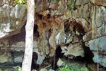
Tham Lod Puyu ( Puyu Passing Through Cave)

Tham Lod Puyu ( Puyu Passing Through Cave)is located at Khao Yakang, to the south of the Park. The ceilings of the cave are formed with exotic stalagmites and stalactites. Along both banks of Puyu canal mangroves grow in abundance. Tham Lod Puyu can be reached by boat from Tammalang Pier, which takes about one hour or two hours for a round trip.
Nam Tok Yaroey (Yaroey Waterfalls)

Nam Tok Yaroey (Yaroey Waterfalls)is approximately 6 kilometers from Thale Ban National Park or 14 kilometers from Khuan Satore T-intersection and a further 300 meters off the main road. The falls boast fabulous cascades and refreshing pools for visitors to relax under the shades of the lush green trees and to take a cool dip in the pools.
Wang Prachan Customs Complex
2 kilometers from Thalae Ban National Park is a gateway to Malaysia. The complex consists of Customs House and Immigration Office. Travellers wishing to proceed to the State of Perlis of Malaysia can pass through here, and it is not far from Padang Besar.
วันเสาร์ที่ 21 มีนาคม พ.ศ. 2552
Thale Ban National Park

Is located in the tropical rain forest areas. In the central part of the park grow pines and the leave shedding trees not commonly found in other parts of the South. Other species of flora can also be found. Species of wildlife abound.
AMPHOE KHUAN DON
Duson Irrigation DikeLocation:Village No. 5, Amphoe Khuan Don, 22 kilometers from the town of Satun by Satun-Hatyai Highway No. 406. Duson Irrigation Dike Creates a large reservoir. Further up the reservoir is the area flourished with the lush greenery, steep slopes and caves, an ideal site for mountaineers climbing for scenic views from atop the mountains.
วันอังคารที่ 17 มีนาคม พ.ศ. 2552
Transportation to Ko Bulon

From Hatyai, visitors can use the same modes of transportation and follow the same routes that go to Tarutao. Boats can be boarded at Pak Bara Pier daily, leaving at 14:00 hours and returning at 9:00 hours. One way ticket costs Baht 110 per person. The trip takes one and a half-hour.
FacilitiesFood and lodging services are available on the island.1. Moolone Bungalows: Reservations can be made at Pak Bara Pier.2. Pan Sand Resort: Reservations can be made at Pak Bara Pier.Accommodation rates range between Bath 100-1,000 per unit/ night.
FacilitiesFood and lodging services are available on the island.1. Moolone Bungalows: Reservations can be made at Pak Bara Pier.2. Pan Sand Resort: Reservations can be made at Pak Bara Pier.Accommodation rates range between Bath 100-1,000 per unit/ night.
Ko Bulon

This is a group of islands in the Phetra Islands National Park, situated about 22 kilometers from Pak Bara Pier. Of all the islands, Ko Bulon Le is the most prominent.Ko Bulon Le, labeled as "Pearl of the Andaman", flourishes with large and small colorful and exotic corals and species of fish such as tiger fish, starfish, etc. It is a must for underwater enthusiasts who enjoy diving into the world of beauty endowed by nature. Bulon is not only reputed for its extravagant underwater beauty, it also boasts shady casuarina lined white sandy beaches, crystal clear navy blue waters, and the charming and hospitable way of life of the Chao Le inhabitants in addition to its tranquillity and unspoiled nature. It is a mecca for those who seek solitude and true beauty of nature.
Things to see & do sights & experiences
An area off the coast of Amphoe La-ngu, over one kilometer from Hua Hin village, lies two islands known officially as "Ko Liki", the islands in the Petra Islands National Park. Lidi islands are a haven for visitors who want privacy because the islands are small and uninhibited. The only buildings found on the island belong to the staff of a private company which has been granted a concession of the precious swallows' nests. Although there are thousands of swallows inhabiting the caves, their flocks cannot be seen easily because the caves where they nestle are accessible only bydiving along the narrow paths. The charm of Lidis lies on the twin islands of almost equal size and three or four islets to the south. Normally these islets are under the water; however, during the low tide they emerge along with the sand dunes linking the islands with the islets. Islanders can walk to explore the real, mysterious, and charming ambiec created by nature. The charms of Lidis are not well known to visitors due to the fact that there are many other beautiful places nearby; thus, the site has been overlooked by visitors although it is more convenient to reach that many other islands.Currently Lidi, is the home of the Warden Unit of Petra Islands National Park. Accommodation has been built and camp grounds are provided for visitors for overninght stay. To reach Lidi, visitors may take a 5-kilometer trip from La - ngu by car or motorcycle to Hua Hin village or a 7- kilometer trip to Ao Noon (the site of the office of Petra Island National Park). From both places , a fisherman's boat can be hired with reasonable prices to take visitors to the twin islands. The trip is guaranteed to be worth the money.
Ko Khao Yai (Big Hill Island)
Ko Khao Yai, part of Petra Islands National Park, lies to the west of Pak Bara Pier. Admired from afar, the shape of the island resembles a stone castle. At one end of the island is a natural stone gate which juts into the sea where a small boat can pass through. The area is where the Satun Aquaculture Office is located. On the other side of the island is a large U-shaped bay 700 meters wide. During the low tide, a cluster of corals can be seen parallel with the shores. The waters around the gulf are calm all year round;pearls are cultured here. Tourists can also visit the pearl culture farms. Koh khao Yai can be reached by various means of transportation; however, the most convenient way is to take a boat from Pak Bara Pier.
Hat Rawai (Rawai Beach)
Hat Rawai is part of Phetra Islands National Park. It is located at Village No. 2 and 4, Tambon Khon Khlan, Amphoe Thung Wa, 26 kilometers from the district office. To get there, drive along La - ngu - Thung Wa road; take a turn at the intersection at Baan Wangtong, Village No. 4, Tambon Nathon ; take another turn at the intersection that leads to Ban Sila. The beach was once accessible by motorcycle only but now it can be reached by car. Hat Rawai is approximately 3,500 meters long. To the north of the beach lies Khlong (canal) Wang Won and on the west side Ko Sukon of Trang Province, can be seen. The beach is lined with casuarina trees. It is recommended for camping.
Phetra Islands National Park

Geographically, Pethra Islands are a national park located in the Straits of Malacca in the Andaman Sea of the Indian Ocean. The area is partly under the administrative jurisdiction of Tambon Ko Sokon, Amphoe Palian, Trang Province; Tambon Khon Khlan, Amphoe Thung Wa, and Tambon Pak Nam, Amphoe La-ngu, Satun Province. The park covers 22 islands with a total area (land and sea) of 208,987 rai or an equivalent of 491.38 square kilometers. Thailand - Malaysia borders lie 30 kilometers away to the south of the park. The Phetra Islands National Park was established in 1973 and its establishment was proclaimed in the Royal Gazette in 1994 as the 49th park in the country's national park system. The main islands which constitute the park are Ko Lidi, Ko Bulon, Ko Khao Yai, and Ko Phetra, etc. Because Phetra Islands National Park is the host of nature's beauty, virgin forests, untouched mountains, it is flourished with bountiful species of wildlife in addition to the picturesque and colorful corals in the sea.
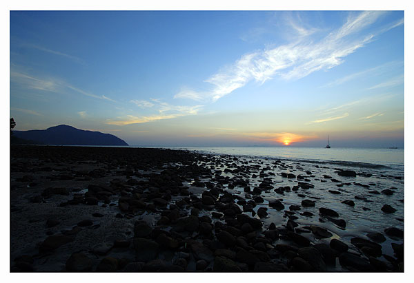
Hat Pak Bara (Pak Bara Beach)
Hat Pak Bara is located in Tambon Pak Nam, Amphoe La-ngu. The pristine beach runs along the 4-kilometer road from La-ngu to Pak Bara Pier. The casuarina trees on both the sides of the road make the ride pleasant and memorable. Hat Pak Bara is suitable for short time excursionists who seek privacy and tranquillity or want to go on a picnic or for group tourists who want to camp out on the beach. The charms of Hat Pak Bara lie not in the sparkling waves or colorful seashells on the sand, but in the numerous picturesque inlands which form a panoramic view from the shore. The greyish profile of Langkawi and Tarutao Islands which contrasts the blue horizon adds a precious asset to Pak Bara's tranquillity. Those who have some knowledge of the history of Tarutao are able to appreciate the melancholy and loneliness suffered by those who were detained on the island and those who awaited the return of their loved ones. In those times, Tarutao, surrounded by the impregnable natural fortress of deep sea, was too far a distance to make a getaway. The only crowded scene can be experienced at Pak Bara Pier at the end of La-ngu -Pak Bara road, where there are regular boat services for tourists to various islands. The boats are of private ownership, Tarutao National Park, and deep sea fishing boats, berthed on the shore and at the pier for transshipment of goods.
Satta Khuha Cave
It's located at Village No. 10, Tambon Nam Phood, Amphoe La-ngu. Tham Satta Khuha is a large limestone cave with exotic stalagmites and stalactites. The cave ceilings are nestled with a large number of bats. A stream winds through the passage of the cave, an ideal site for spelunkers to canoe along the stream. The cave is located in the Khao Banthad's Wildlife Conservation Area.
Ko Bo Chet Luk (Seven-Well Island)
This island is only about 2 kilometers from Pak Bara Pier. There are many beautiful beaches on the island, of which the most intruguing is Hat Ka Sing. The serene atmosphere, the clean fine sand on the stretch of beach, rocks of magnificient shapes, and the simple and friendly way of life of the fishermen's community, all make a visit to the island a memorable one. To get to the island, take a long tail boat from Pak Bara Pier.
วันจันทร์ที่ 16 มีนาคม พ.ศ. 2552
Old Buildings on Buri Wanich Road

Khao Phaya Wang ( Phaya Wang Hill )
Located on Khuha Prawase Road in the municipality area. Khao Phaya Wang is a limestone hill with a cave, and beautifully shaped stalagmites, stalactites and overhanging rocks. On the northern side is a small stream running along the hill. The area around Khao Phya Wang has been developed by Satun Municipality as a public park for the people to relax. It is convenient to reach this hill.
Central Mosque (Masjid Mambang)

It is located on Satun Thani Road in the Municipality of Satun. Previously Masjid Bambang was a one storey building . Its unique three - tier roofs were arranged in a pyramid shape with the smallest one on the top and the largest at the bottom to cover the whole building. The floors were covered with brown tiles. The interior was measured 13 meters both in length and width and the building was supported by four wooden poles. The condition of the Masjid has deteriorated because of its wooden structures and also the size was too small to accommodate worshippers performing prayers. It was then uprooted and rebuilt in the same plot of land. The new building, showing modern Islamic architectural style, was completed in May 1979.
Tourist Attractions
 AMPHOE MUANG
Ku Den 's Mansion
Located in the municipality area, opposite Land Department Office, Ku Den 's Mansion was formerly a residence of Rong Ammarttri Phraya Phuminart Phakdi ( Tuanku Baharuddin bin Tamma-ngong ), the governor of Satun.
The two-storey building got the influenced of western styled architecture; particularly the windows and doors which are of Roman motifs. The roofs were designed in the Thai 's Panya style. The windows were assembled with narrow strips of boards arranged horizontally. The semi - circular clay tiles were used to cover the roofs. The ventilation at the upper-front of the building is decorated with starshaped designs , imminently influenced by Muslim architecture . Ku Den's Mansion was later donated to the government and was used as governmental offices such as Satun Municipality , Provincial City Hall , Satun District Office, and Office of Internal Security Operations Command - Satun Branch, respectively. Now the building is under the jurisdiction of Fine Arts Department for maintenance and preservation, and in the near future it is to be turned into a Museum for Islamic Studies.
Introduction in Satun
Introduction
Satun is a province in the South of Thailand that borders Malaysia. Situated on the west coast in the vicinity of the Straits of Malacca in the Indian Ocean. Satun, is about 973 kilometers. Its total area of 2,478.98 square kilometers also encompasses 105 islands. The mainland's shoreline extends 144.80 kilometers in length.

Prior to A.D. 1813, Satun was a district of Kedah, known as Mukim Setul, meaning "the district of santol tree" Historical , Satun had a strong link with Kedah until A.D. 1909, under the Anglo-Siamese Agreement, when the Siamese government then agreed to relinquish the states of Kedah, Kelantan, Tregganu, and Perlis to Britain in exchange for the British's renunciation of its Extra-territorial Rights in Siam (former of Thailand). The consequence of the Anglo-Siamese Agreement shifted the status of Satun from being part of Kedah to that of Phuket and later in 1925 was under the jurisdiction of Nakhon Si Thammarat. When decromatic reform was one of the provinces in the South. Satun consists of six adminstrative districts (Amphoe) and one subdistrict (King amphoe): Amphoe Muang Satun, La-ngu, Thun Wa, Khuan Kalong, Khuan Don, Tha Phae; and King Amphoe Manang. The unique bi-cultural characteristics of the people in Satun reflect social harmony among the people of two faiths: Buddhists and Muslims. In addition, Satun also hosts the cultures of an indigenous group called Chao Le (Orak Lawoi, Orang Laut or Sea Gypsies) or an official label of Thai Mai (recently naturalized Thai) whose settlements can be found on Lipeh Islands, Tambon Ko Sarai, Amphoe Muang Satun; and on Bulone Island. These people observe distinctively different cultures and traditions from those of the local people.
Location
Satun is the southernmost province of Thailand on the west coast bordering Malaysia and other Amphoes and province as follows:
North
borders Amphoe Rattapoom of Songkhla, Amphoe Pa bon of Phattalung and Amphoe Pa Lian of Trang.
East
borders Amphoe Sadao of Songkhla and Perlis of Malaysia.
South
borders Perlis of Malaysia.
West
borders Andaman Sea of India Ocean
Distance from Amphoe Muang Satun to other Amphoe (districts)
La-ngu 50 kms.
Tha Phae 28 kms.
Khuan Don 20 kms.
Khuan Ka-long 29 kms.
Thung Wa 76 kms.
Manang Subdistrict 65 kms.
สมัครสมาชิก:
บทความ (Atom)